用户:StephDC/Sandbox0
高度计是用来测量物体水平高度,即海拔的工具。高度的测量被称为测高,与测深,即测量水下深度类似。
目录
气压高度计
海拔高度可通过测量大气压得到。当一只气压表被标上与海拔高度的气压一致的非线性刻度时,这个气压表即可被称为气压高度计或大气高度计。气压高度计是在飞行器上最常见的高度计,而跳伞玩家也常使用绑在腰上的气压高度计来做类似用途。登山者常用系在手腕上或手持式的高度计以帮助他们使用地图、指南针或GPS定位。
气压高度计的校准可以使用以下公式进行:
- <math>z=c\;T\;\log(P_o/P),</math>[1]
此时 c 为常数, T 为绝对温度, P 为在高度 z 处的气压,而 P0 为在海平面处的大气压。常数 c 与重力加速度和空气的摩尔质量相关。
但是,由于气压高度计基于“密度高度”,而所指示的数值可以在受到类似冷锋面气流冲击等而发生瞬时气压改变时轻易产生数百英尺的误差。[2]
在登山运动上的应用
一只气压高度计在与等高线地图共同使用时可以帮助确认当前的地理位置。通常情况下,气压高度计在用于测量海拔时,比起GPS高度计要更加可靠并且准确,因为GPS高度计在例如峡谷底部等地可能不可用,或在例如所有可用卫星都在地平线附近时给出具有极大误差的数据。而由于大气压会随著天气的变化而变化,因此登山者需要每到一个已知的高度时,例如到达路线交叉点或于等高线地图上标明的峰顶时就重新校准气压高度计。
在飞行器上的应用

In aircraft, an aneroid barometer measures the atmospheric pressure from a static port outside the aircraft. Air pressure decreases with an increase of altitude—approximately 100 hectopascals per 800 meters or one inch of mercury per 1000 feet near sea level.
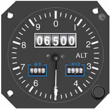
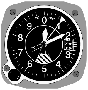
The aneroid altimeter is calibrated to show the pressure directly as an altitude above mean sea level, in accordance with a mathematical model defined by the International Standard Atmosphere (ISA). Older aircraft used a simple aneroid barometer where the needle made less than one revolution around the face from zero to full scale. This design evolved to altimeters with a primary needle and one or more secondary needles that show the number of revolutions, similar to a clock face. In other words, each needle points to a different digit of the current altitude measurement. However this design has fallen out of favor due to the risk of misreading in stressful situations. The design evolved further to drum-type altimeters, the final step in analogue instrumentation, where each revolution of a single needle accounted for 1,000 feet, with thousand foot increments recorded on a numerical odometer-type drum. To determine altitude, a pilot had first to read the drum to determine the thousands of feet, then look at the needle for the hundreds of feet. Modern analogue altimeters in transport aircraft are typically drum-type. The latest development in clarity is an Electronic flight instrument system with integrated digital altimeter displays. This technology has trickled down from airliners and military planes until it is now standard in many general aviation aircraft.
Modern aircraft use a "sensitive altimeter,". On a sensitive altimeter, the sea-level reference pressure can be adjusted with a setting knob. The reference pressure, in inches of mercury in Canada and the US and hectopascals (previously millibars) elsewhere, is displayed in the small Kollsman window,[3] on the face of the aircraft altimeter. This is necessary, since sea level reference atmospheric pressure at a given location varies over time with temperature and the movement of pressure systems in the atmosphere.
In aviation terminology, the regional or local air pressure at mean sea level (MSL) is called the QNH or "altimeter setting", and the pressure that will calibrate the altimeter to show the height above ground at a given airfield is called the QFE of the field. An altimeter cannot, however, be adjusted for variations in air temperature. Differences in temperature from the ISA model will accordingly cause errors in indicated altitude.
In aerospace, the mechanical stand-alone altimeters which are based on diaphragm bellows were replaced by integrated measurement system which is called Air data computer (ADC). This module measures altitude, speed of flight and outside temperature to provide more precise output data allowing automatic flight control and Flight level division. Multiple altimeters can be used to design a Pressure Reference System to provide information about airplane's position angles to further support Inertial navigation system calculations.
在地面效应载具中的使用
经过广泛的研究和实验,已经证明相对于激光、各向同性或超声波测高计,“相无线电测高计”是最适合地面效应载具。[4]
声波高度计
1931年,美国陆军航空队和通用电气测试了一款为飞机设计的声波高度计,在雨天或者雾天这款测高仪有着明显高于空气压力高度计的精确度。这款声波高度计采用了类似蝙蝠的高频声波来衡量飞机与地面的距离,并转换成以英尺表示的数值显示在飞机上的一个仪表盘里。[5]
雷达高度计
雷达高度计测量高度的方法更加直接:通过计算一个无线电讯号从地面反射回来的时间来判断高度。现在雷达高度计一般用于商用或军用飞机降落时的高度测量和警告飞行员高度过低或者前方有上升地形。后者通常用于一些低空飞行的战斗机。
GPS
全球卫星定位系统(GPS)接收器也可以通过与四个或更多的卫星进行三边测量来判断高度。但在飞机上,如果不使用一些方法来提高精确度,GPS本身的精确度并无法取代压力测高仪。在徒步旅行或者登山时,我们经常可以发现GPS测量的高度误差可以达到1000米以上。当所有可用的卫星都接近地平线时GPS也会无法使用。
Other modes of transport
The altimeter is an instrument optional in off-road vehicles to aid in navigation. Some high-performance luxury cars that were never intended to leave paved roads, such as the Duesenberg in the 1930s, have also been equipped with altimeters.
Hikers and mountaineers use hand-held or wrist-mounted barometric altimeters, as do skydivers.
Diesel submarines have barometers installed on them to monitor vacuum being pulled in the event that the snorkel closes while the diesels are running and, as a consequence, sucking the air out of the boat.
Satellites

Many satellites (see links) use advanced dual-band radar altimeters to measure height from a spacecraft. That measurement, coupled with orbital elements (possibly augmented by GPS), enables determination of the terrain. The two different wavelengths of radio waves used permit the altimeter to automatically correct for varying delays in the ionosphere.
Spaceborne radar altimeters have proven to be superb tools for mapping ocean-surface topography, the hills and valleys of the sea surface. These instruments send a microwave pulse to the ocean's surface and record the time it takes to return. A microwave radiometer corrects any delay that may be caused by water vapor in the atmosphere. Other corrections are also required to account for the influence of electrons in the ionosphere and the dry air mass of the atmosphere. Combining these data with the precise location of the spacecraft makes it possible to determine sea-surface height to within a few centimetres (about one inch). The strength and shape of the returning signal also provides information on wind speed and the height of ocean waves. These data are used in ocean models to calculate the speed and direction of ocean currents and the amount and location of heat stored in the ocean, which in turn reveals global climate variations.
See also
- Acronyms and abbreviations in avionics
- Flight instruments
- Flight level
- seasat, TOPEX/Poseidon are satellites that deployed extremely accurate altimeters
- United Airlines Flight 389, an accident attributed to misreading of an altimeter
- Turkish Airlines Flight 1951, an accident attributed to a malfunctioning radio altimeter
- Jason-1, Ocean Surface Topography Mission/Jason-2 are current satellite missions that use altimeters to measure sea surface height
References
- ↑ http://www.hills-database.co.uk/altim.html
- ↑ "How Aircraft Instruments Work." Popular Science, March 1944, p. 118.
- ↑ http://www.stolaf.edu/people/hansonr/soaring/altimetr.htm
- ↑ Nebylov, Prof. Alexander and Sharan Sukrit. "Comparative Analysis Of Design Variants For Low Altitude Flight Parameters Measuring System". 17th IFAC Symposium for Automatic Control.
- ↑ "Meter Gives Elevation", Popular Science, March 1931
External links
- MS5561C Micro Altimeter for GPS, 1m resolution
- History of the Kollsman altimeter
- A Flash 8 based simulator for altimeter errors caused by variations in temperature and pressure
- The use of altimeters in height measurement – for hillwalkers
- Compact digital pressure sensor for altimeters
- Early use of barometers on surveys
- The altimeter and the types of altitude
- Evolution of the Modern Altimeter – Flight archive
Template:Flight instruments Template:Aircraft components Template:Aviation lists

